Geolocate

Oberems topographic map

Click on the map to display elevation.

About this map

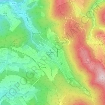
Name: Oberems topographic map, elevation, terrain.

Location: Oberems, Glashütten, Hochtaunuskreis, Hesse, Germany (50.22196 8.37729 50.25888 8.43648)

Average elevation: 1,575 ft

Minimum elevation: 1,024 ft

Maximum elevation: 2,293 ft

Other topographic maps

Click on a map to view its topography, its elevation and its terrain.

Schmitten

Germany > Hesse > Hochtaunuskreis > Schmitten

Average elevation: 1,752 ft

Gear up for your next adventure:

🎒Outdoor Daypacks - Lightweight backpacks designed for carrying maps and essential gear
🛰️Handheld GPS Units - Professional satellite navigators for precise backcountry mapping
📡Handheld GPS Device - Reliable handheld GPS for outdoor navigation
🚁Photography Drones - Capture stunning aerial views of landforms and topography
🧭Outdoor Navigation Book - Learn advanced navigation skills

As an Amazon Associate, this site earns from qualifying purchases at no extra cost to you.