
Village of Dundee topographic map
Interactive map
Click on the map to display elevation.
About this map
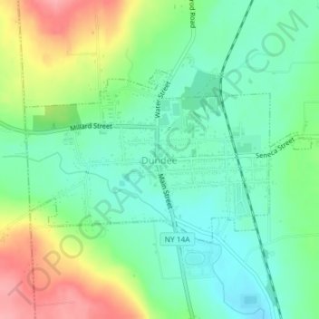
Name: Village of Dundee topographic map, elevation, terrain.
Average elevation: 1,047 ft
Minimum elevation: 922 ft
Maximum elevation: 1,283 ft
Other topographic maps
Click on a map to view its topography, its elevation and its terrain.
Seneca Lake
United States > New York > Yates County > Town of Lodi
Seneca Lake, Town of Lodi, Town of Torrey, Yates County, New York, United States
Average elevation: 955 ft
Keuka Lake
United States > New York > Yates County > Keuka Park
Keuka Lake, Keuka Park, Town of Jerusalem, Yates County, New York, 14840, United States
Average elevation: 1,250 ft
Town of Jerusalem
United States > New York > Yates County
Town of Jerusalem, Yates County, New York, United States
Average elevation: 1,260 ft
Porter Corner
United States > New York > Yates County > Town of Barrington
Porter Corner, Town of Barrington, Yates County, New York, United States
Average elevation: 1,417 ft
Keuka Park
United States > New York > Yates County
Keuka Park, Town of Jerusalem, Yates County, New York, United States
Average elevation: 804 ft
Village of Penn Yan
United States > New York > Yates County
Village of Penn Yan, Town of Milo, Yates County, New York, 14527, United States
Average elevation: 837 ft
Benton Center
United States > New York > Yates County > Town of Benton > Benton Center
Benton Center, Town of Benton, Yates County, New York, United States
Average elevation: 1,040 ft
Bellona
United States > New York > Yates County > Bellona
Bellona, Benton, Yates County, New York, 14415, United States
Average elevation: 787 ft