
Make a donation
Gear up for your next adventure:
As an Amazon Associate, this site earns from qualifying purchases at no extra cost to you.
Keuka Lake topographic map
Click on the map to display elevation.
Make a donation
Gear up for your next adventure:
As an Amazon Associate, this site earns from qualifying purchases at no extra cost to you.
Keuka Lake
In 1788 the township of Jerusalem, New York was founded by a Quaker Evangelist preacher, Jemima Wilkinson, who, after recovering from a near-death illness, referred to herself as the Public Universal Friend. Wilkinson, with a following of twenty-five other settlers, began to clear twenty-five acres of forest and built a number of log cabins along the creek which led from Keuka Lake to Seneca Lake. As the surface elevation of Keuka Lake was more than 260 feet higher than Seneca Lake, it was considered an ideal location for a grist mill, with the outlet creek providing water power. By 1790 the religious congregation numbered two hundred and sixty. Together they built the first frame house on Keuka Lake Outlet for their leader. it was a large two-story structure that housed nine fireplaces about a central chimney. A thirty-foot-square log meeting house for religious services was also built. Wilkinson and her followers remained here from 1790 to 1794. In 1790 the first mill was established at the falls of the creek. In 1794 the first sawmill to emerge inside the village limits of Penn Yan was established by Lewis Birdsall, who commissioned Enoch Malin to oversee its construction on the outlet's north bank. In the following years there was much growth along the length of the outlet. By 1820 there were 14 sawmills, 7 grist mills, several distilleries, an oil mill, 4 carding machines, all of which made use of local raw materials such as wheat, timber, flaxseed, wool and corn.
Make a donation
Gear up for your next adventure:
As an Amazon Associate, this site earns from qualifying purchases at no extra cost to you.
About this map
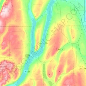
Name: Keuka Lake topographic map, elevation, terrain.
Average elevation: 1,250 ft
Minimum elevation: 666 ft
Maximum elevation: 2,077 ft
Yates County trails, hiking, mountain biking, running and outdoor activities
Make a donation
Gear up for your next adventure:
As an Amazon Associate, this site earns from qualifying purchases at no extra cost to you.