Geolocate

Central topographic map

Click on the map to display elevation.

About this map

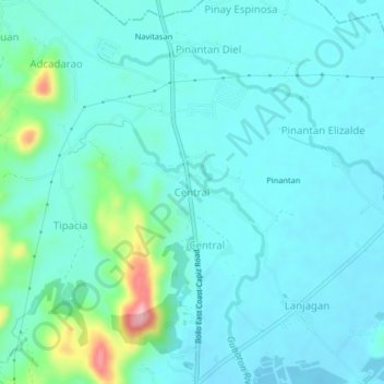
Name: Central topographic map, elevation, terrain.

Location: Central, Iloilo, Western Visayas, Philippines (11.17879 123.00361 11.21879 123.04361)

Average elevation: 85 ft

Minimum elevation: -10 ft

Maximum elevation: 515 ft

Other topographic maps

Click on a map to view its topography, its elevation and its terrain.

Anilao

Philippines > Iloilo > Anilao

Average elevation: 171 ft

Balasan

Philippines > Iloilo

Average elevation: 138 ft

Miagao

Philippines > Iloilo

Average elevation: 318 ft

Bayas Island

Philippines > Iloilo > Estancia > Bayas

Average elevation: 3 ft

Banate

Philippines > Iloilo

Average elevation: 112 ft

Balbagon Island

Philippines > Iloilo > Carles

Average elevation: 0 ft

Lambunao

Philippines > Iloilo > Lambunao

Average elevation: 417 ft

Gear up for your next adventure:

🗃️Trail First Aid Kit - Essential kit for outdoor injuries and emergencies
📡Handheld GPS Device - Reliable handheld GPS for outdoor navigation
🦶Hiking Gaiters - Keep debris and water out of your boots
🥾Hiking Shoes - Durable and comfortable shoes for trail hiking
📷Action Camera - Capture your outdoor adventures in HD

As an Amazon Associate, this site earns from qualifying purchases at no extra cost to you.