
Thank you for supporting this site ❤️
Make a donation
Make a donation
Gear up for your next adventure:
As an Amazon Associate, this site earns from qualifying purchases at no extra cost to you.
Celanova topographic map
Click on the map to display elevation.
Thank you for supporting this site ❤️
Make a donation
Make a donation
Gear up for your next adventure:
As an Amazon Associate, this site earns from qualifying purchases at no extra cost to you.
About this map
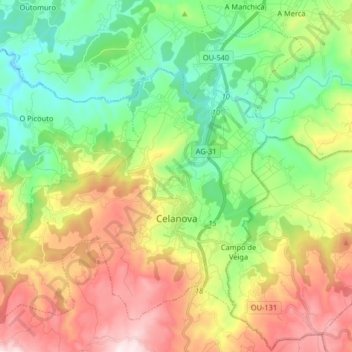
Name: Celanova topographic map, elevation, terrain.
Location: Celanova, Terra da Celanova, Ourense, Galicia, Spain (42.11528 -8.06270 42.21797 -7.89968)
Average elevation: 1,755 ft
Minimum elevation: 906 ft
Maximum elevation: 3,097 ft
Thank you for supporting this site ❤️
Make a donation
Make a donation
Gear up for your next adventure:
As an Amazon Associate, this site earns from qualifying purchases at no extra cost to you.