
Make a donation
Gear up for your next adventure:
As an Amazon Associate, this site earns from qualifying purchases at no extra cost to you.
Boborás topographic map
Click on the map to display elevation.
Make a donation
Gear up for your next adventure:
As an Amazon Associate, this site earns from qualifying purchases at no extra cost to you.
About this map
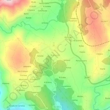
Name: Boborás topographic map, elevation, terrain.
Location: Boborás, O Carballiño, Orense, Galicia, 32514, España (42.41178 -8.16300 42.45178 -8.12300)
Average elevation: 1,352 ft
Minimum elevation: 715 ft
Maximum elevation: 2,096 ft
Make a donation
Gear up for your next adventure:
As an Amazon Associate, this site earns from qualifying purchases at no extra cost to you.
Other topographic maps
Click on a map to view its topography, its elevation and its terrain.
Piñor
España > Galicia > O Carballiño
La orografía del término municipal aparece definida por dos unidades morfológicas. La primera está constituida por los conjuntos montañosas periféricos que bordean el término municipal por el norte y por el oeste, donde las altitudes son significativas, entre los 800-900 metros, especialmente en las…
Average elevation: 2,244 ft
Punxín
España > Galicia > O Carballiño
El relieve del municipio está caracterizado por el río Barbantiño, que desemboca en el Miño en el límite sur del municipio, y los montes que se alzan al oeste del mismo, destacando al sur y al suroeste el Monte de San Trocado, que alcanza los 553 metros de altitud. La altitud oscila entre los 553 metros y…
Average elevation: 978 ft
Make a donation
Gear up for your next adventure:
As an Amazon Associate, this site earns from qualifying purchases at no extra cost to you.
Beariz
España > Galicia > O Carballiño
Al norte y oeste del municipio es donde se alcanzan las mayores altitudes (Marcofán, 940 metros).
Average elevation: 2,257 ft
San Cristovo de Cea
España > Galicia > O Carballiño
En cuanto al relieve, existen dos zonas bien diferenciadas. La zona norte ocupa dos tercios del territorio y está surcada por una cadena montañosa que une Serra da Martiña (1039 metros) con Serra da Madanela, ya en Piñor, en dirección nordeste-suroeste. La zona sur, limitante con Carballino y Piñor,…
Average elevation: 2,008 ft
Make a donation
Gear up for your next adventure:
As an Amazon Associate, this site earns from qualifying purchases at no extra cost to you.
Make a donation
Gear up for your next adventure:
As an Amazon Associate, this site earns from qualifying purchases at no extra cost to you.
Make a donation
Gear up for your next adventure:
As an Amazon Associate, this site earns from qualifying purchases at no extra cost to you.
Make a donation
Gear up for your next adventure:
As an Amazon Associate, this site earns from qualifying purchases at no extra cost to you.
Punxín
España > Galicia > O Carballiño
El relieve del municipio está caracterizado por el río Barbantiño, que desemboca en el Miño en el límite sur del municipio, y los montes que se alzan al oeste del mismo, destacando al sur y al suroeste el Monte de San Trocado, que alcanza los 553 metros de altitud. La altitud oscila entre los 553 metros y…
Average elevation: 978 ft