
Thank you for supporting this site ❤️
Make a donation
Make a donation
Gear up for your next adventure:
As an Amazon Associate, this site earns from qualifying purchases at no extra cost to you.
Kepahiang topographic map
Click on the map to display elevation.
Thank you for supporting this site ❤️
Make a donation
Make a donation
Gear up for your next adventure:
As an Amazon Associate, this site earns from qualifying purchases at no extra cost to you.
About this map
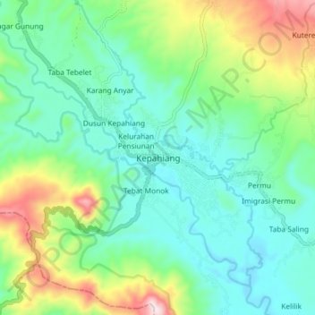
Name: Kepahiang topographic map, elevation, terrain.
Location: Kepahiang, Bengkulu, Sumatra, 39372, Indonesia (-3.68536 102.53891 -3.60536 102.61891)
Average elevation: 1,985 ft
Minimum elevation: 1,539 ft
Maximum elevation: 3,153 ft
Thank you for supporting this site ❤️
Make a donation
Make a donation
Gear up for your next adventure:
As an Amazon Associate, this site earns from qualifying purchases at no extra cost to you.