Geolocate

Saginaw topographic map

Click on the map to display elevation.

About this map

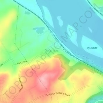
Name: Saginaw topographic map, elevation, terrain.

Location: Saginaw, East Manchester Township, York County, Pennsylvania, United States (40.06184 -76.67793 40.06761 -76.66941)

Average elevation: 394 ft

Minimum elevation: 233 ft

Maximum elevation: 676 ft

Other topographic maps

Click on a map to view its topography, its elevation and its terrain.

Gear up for your next adventure:

🔥Camping Stove - Portable stove for camping and backcountry cooking
🧦Merino Wool Socks - Moisture-wicking, blister-preventing socks for long treks
🧦Hiking Socks - Comfortable socks to prevent blisters on long hikes
🥾Women's Hiking Boots - Top-rated trail boots with ankle support and superior grip
🪶Thermal Camp Blanket - Extra warmth for cold nights

As an Amazon Associate, this site earns from qualifying purchases at no extra cost to you.