
Make a donation
Gear up for your next adventure:
As an Amazon Associate, this site earns from qualifying purchases at no extra cost to you.
Müsen topographic map
Click on the map to display elevation.
Make a donation
Gear up for your next adventure:
As an Amazon Associate, this site earns from qualifying purchases at no extra cost to you.
Müsen
Müsen liegt oberhalb von Hilchenbach-Dahlbruch im nördlichen Siegerland. Der Ort liegt auf ca. 340 m im Rothenbachtal, einer nach Süden geöffneten Mulde, zwischen der Martinshardt mit 616,1 m Höhe, dem Kindelsberg mit 617,9 m Höhe, dem Ziegenberg mit 521 m Höhe und dem Breitenberg mit 529 m Höhe. Höchster Berg in der Umgebung ist der Hohe Wald mit 655 m Höhe.
Make a donation
Gear up for your next adventure:
As an Amazon Associate, this site earns from qualifying purchases at no extra cost to you.
About this map
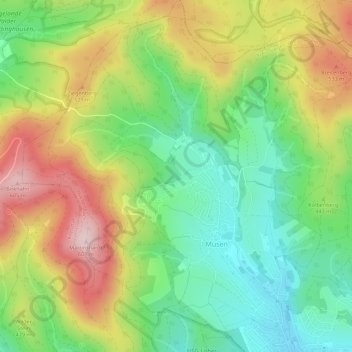
Name: Müsen topographic map, elevation, terrain.
Average elevation: 1,440 ft
Minimum elevation: 1,040 ft
Maximum elevation: 1,988 ft
Make a donation
Gear up for your next adventure:
As an Amazon Associate, this site earns from qualifying purchases at no extra cost to you.
Other topographic maps
Click on a map to view its topography, its elevation and its terrain.
Grund
Deutschland > Nordrhein-Westfalen > Kreis Siegen-Wittgenstein > Hilchenbach
Average elevation: 1,493 ft
Helberhausen
Deutschland > Nordrhein-Westfalen > Kreis Siegen-Wittgenstein > Hilchenbach
Average elevation: 1,604 ft
Vormwald
Deutschland > Nordrhein-Westfalen > Kreis Siegen-Wittgenstein > Hilchenbach
Average elevation: 1,562 ft
Buchenhain
Deutschland > Nordrhein-Westfalen > Kreis Siegen-Wittgenstein > Hilchenbach
Average elevation: 1,821 ft
Make a donation
Gear up for your next adventure:
As an Amazon Associate, this site earns from qualifying purchases at no extra cost to you.
Helberhausen
Deutschland > Nordrhein-Westfalen > Kreis Siegen-Wittgenstein > Hilchenbach
Average elevation: 1,604 ft