
Salekhard topographic map
Interactive map
Click on the map to display elevation.
About this map
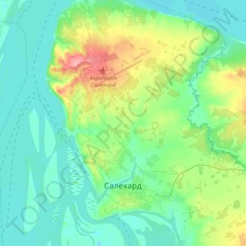
Name: Salekhard topographic map, elevation, terrain.
Average elevation: 72 ft
Minimum elevation: -7 ft
Maximum elevation: 318 ft
Other topographic maps
Click on a map to view its topography, its elevation and its terrain.
Salekhard
Russia > Yamalo-Nenets Autonomous Okrug > Salekhard Urban Okrug > Salekhard
Salekhard, Salekhard Urban Okrug, Yamalo-Nenets Autonomous Okrug, Ural Federal District, 629004, Russia
Average elevation: 69 ft