
Thank you for supporting this site ❤️
Make a donation
Make a donation
Gear up for your next adventure:
As an Amazon Associate, this site earns from qualifying purchases at no extra cost to you.
Limbon topographic map
Click on the map to display elevation.
Thank you for supporting this site ❤️
Make a donation
Make a donation
Gear up for your next adventure:
As an Amazon Associate, this site earns from qualifying purchases at no extra cost to you.
About this map
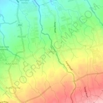
Name: Limbon topographic map, elevation, terrain.
Location: Limbon, Indang, Cavite, Calabarzon, 4122, Philippines (14.18035 120.88177 14.22035 120.92177)
Average elevation: 1,037 ft
Minimum elevation: 801 ft
Maximum elevation: 1,319 ft
Thank you for supporting this site ❤️
Make a donation
Make a donation
Gear up for your next adventure:
As an Amazon Associate, this site earns from qualifying purchases at no extra cost to you.