
Make a donation
Gear up for your next adventure:
As an Amazon Associate, this site earns from qualifying purchases at no extra cost to you.
Pucón topographic map
Click on the map to display elevation.
Make a donation
Gear up for your next adventure:
As an Amazon Associate, this site earns from qualifying purchases at no extra cost to you.
Pucón
El Cañi, meaning “sight that transforms”, is a private protected area of 500 hectares belonging to a non-profit organization. It contains hiking trails through ancient araucarias, lengas, coigues, old volcanic craters and lagoons. It is administered by a group of farmers. The park is home to foxes, pumas, pudús (a small kind of deer), wild ducks and condors, among many other species. A view point located at 1,550 meters altitude provides views of four nearby volcanoes: Villarrica, Quetrupillán, Lanín and Llaima.
Make a donation
Gear up for your next adventure:
As an Amazon Associate, this site earns from qualifying purchases at no extra cost to you.
About this map
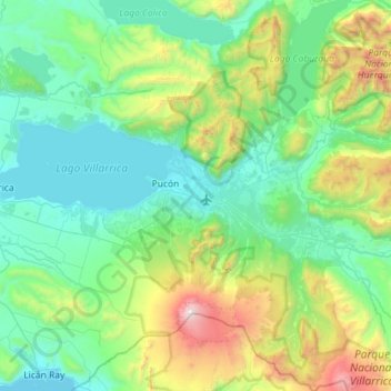
Name: Pucón topographic map, elevation, terrain.
Location: Pucón, Provincia de Cautín, Araucania Region, Chile (-39.50847 -72.06910 -39.06603 -71.50180)
Average elevation: 2,418 ft
Minimum elevation: 659 ft
Maximum elevation: 9,295 ft
Make a donation
Gear up for your next adventure:
As an Amazon Associate, this site earns from qualifying purchases at no extra cost to you.
Other topographic maps
Click on a map to view its topography, its elevation and its terrain.
Make a donation
Gear up for your next adventure:
As an Amazon Associate, this site earns from qualifying purchases at no extra cost to you.
Volcán Llaima
Chile > Araucanía Region > Provincia de Cautín > Vilcún
The average elevation of the terrain around Llaima is about 740 m asl.
Average elevation: 8,264 ft
Make a donation
Gear up for your next adventure:
As an Amazon Associate, this site earns from qualifying purchases at no extra cost to you.