
Make a donation
Gear up for your next adventure:
As an Amazon Associate, this site earns from qualifying purchases at no extra cost to you.
Caburgua topographic map
Click on the map to display elevation.
Make a donation
Gear up for your next adventure:
As an Amazon Associate, this site earns from qualifying purchases at no extra cost to you.
About this map
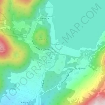
Name: Caburgua topographic map, elevation, terrain.
Location: Caburgua, Provincia de Cautín, Araucanía Region, Chile (-39.21938 -71.82813 -39.17938 -71.78813)
Average elevation: 1,824 ft
Minimum elevation: 1,257 ft
Maximum elevation: 3,468 ft
Make a donation
Gear up for your next adventure:
As an Amazon Associate, this site earns from qualifying purchases at no extra cost to you.
Other topographic maps
Click on a map to view its topography, its elevation and its terrain.
Make a donation
Gear up for your next adventure:
As an Amazon Associate, this site earns from qualifying purchases at no extra cost to you.
Make a donation
Gear up for your next adventure:
As an Amazon Associate, this site earns from qualifying purchases at no extra cost to you.
Villarrica
Chile > Araucanía Region > Provincia de Cautín
Other lakes found nearby include Calafquén, Caburgua, Huilipilún and Colico. In the summer water sports and sunbathing are popular activities in the warm temperatures experienced at the low altitudes ranging from 200 to 500m above sea level.
Average elevation: 1,381 ft
Make a donation
Gear up for your next adventure:
As an Amazon Associate, this site earns from qualifying purchases at no extra cost to you.
Pucón
Chile > Araucanía Region > Provincia de Cautín
El Cañi, meaning “sight that transforms”, is a private protected area of 500 hectares belonging to a non-profit organization. It contains hiking trails through ancient araucarias, lengas, coigues, old volcanic craters and lagoons. It is administered by a group of farmers. The park is home to foxes, pumas,…
Average elevation: 2,418 ft
Villarrica
Chile > Araucanía Region > Provincia de Cautín
Other lakes found nearby include Calafquén, Caburgua, Huilipilún and Colico. In the summer water sports and sunbathing are popular activities in the warm temperatures experienced at the low altitudes ranging from 200 to 500m above sea level.
Average elevation: 1,381 ft
Pucón
Chile > Araucanía Region > Provincia de Cautín
El Cañi, meaning “sight that transforms”, is a private protected area of 500 hectares belonging to a non-profit organization. It contains hiking trails through ancient araucarias, lengas, coigues, old volcanic craters and lagoons. It is administered by a group of farmers. The park is home to foxes, pumas,…
Average elevation: 2,418 ft
Make a donation
Gear up for your next adventure:
As an Amazon Associate, this site earns from qualifying purchases at no extra cost to you.