
Make a donation
Gear up for your next adventure:
As an Amazon Associate, this site earns from qualifying purchases at no extra cost to you.
Pinheira topographic map
Click on the map to display elevation.
Make a donation
Gear up for your next adventure:
As an Amazon Associate, this site earns from qualifying purchases at no extra cost to you.
About this map
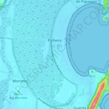
Name: Pinheira topographic map, elevation, terrain.
Average elevation: 16 ft
Minimum elevation: -3 ft
Maximum elevation: 440 ft
Make a donation
Gear up for your next adventure:
As an Amazon Associate, this site earns from qualifying purchases at no extra cost to you.
Other topographic maps
Click on a map to view its topography, its elevation and its terrain.
Cambirela Sul
Brasil > Santa Catarina > Palhoça
O Morro do Cambirela é uma montanha situada no maciço de mesmo nome, no município de Palhoça, no estado de Santa Catarina. Sua altitude é de 1052 metros, o que o torna o ponto culminante do município e da região, destacando-se pelo fato de elevar-se praticamente a partir do nível do mar até mais de um…
Average elevation: 2,270 ft
Make a donation
Gear up for your next adventure:
As an Amazon Associate, this site earns from qualifying purchases at no extra cost to you.