
Make a donation
Gear up for your next adventure:
As an Amazon Associate, this site earns from qualifying purchases at no extra cost to you.
Nivollet topographic map
Click on the map to display elevation.
Make a donation
Gear up for your next adventure:
As an Amazon Associate, this site earns from qualifying purchases at no extra cost to you.
Nivollet
Le village de Montgriffon se situe sur un plateau incliné vers l'ouest et surplombant la vallée de la Mandorne. Le village culmine à une altitude moyenne de 800 mètres. Le point culminant de la commune, qui se situe au lieu-dit Veuillant (« voir loin » en patois bugiste), s'élève à 833 mètres ; il offre un panorama sur la Dombes et la Bresse.
Make a donation
Gear up for your next adventure:
As an Amazon Associate, this site earns from qualifying purchases at no extra cost to you.
About this map
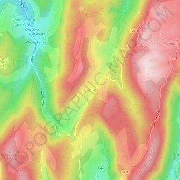
Name: Nivollet topographic map, elevation, terrain.
Average elevation: 2,021 ft
Minimum elevation: 1,086 ft
Maximum elevation: 2,723 ft
Make a donation
Gear up for your next adventure:
As an Amazon Associate, this site earns from qualifying purchases at no extra cost to you.