Geolocate

Vestignano topographic map

Click on the map to display elevation.

About this map

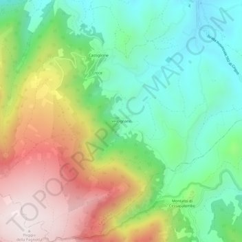
Name: Vestignano topographic map, elevation, terrain.

Location: Vestignano, Caldarola, Macerata, Marche, Italy (43.09762 13.18883 43.13762 13.22883)

Average elevation: 2,067 ft

Minimum elevation: 988 ft

Maximum elevation: 3,770 ft

Gear up for your next adventure:

📻Weather Alert Radios - Stay informed of storm risks while off-the-grid
🛡️Insect Repellent - Protection against bugs during outdoor activities
🛌Ultralight Sleeping Bags - Compact down bags for cold nights in the wilderness
📚USA Hiking Guide Books - Top trail guides and map books
🔊Portable Camp Speaker - Music and alerts at camp

As an Amazon Associate, this site earns from qualifying purchases at no extra cost to you.