
Make a donation
Gear up for your next adventure:
As an Amazon Associate, this site earns from qualifying purchases at no extra cost to you.
North Hebron topographic map
Click on the map to display elevation.
Make a donation
Gear up for your next adventure:
As an Amazon Associate, this site earns from qualifying purchases at no extra cost to you.
About this map
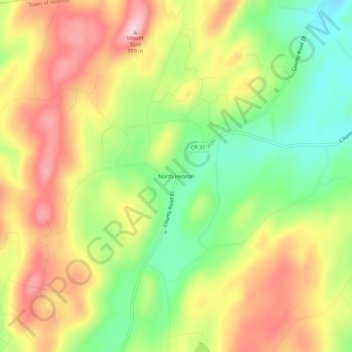
Name: North Hebron topographic map, elevation, terrain.
Average elevation: 938 ft
Minimum elevation: 581 ft
Maximum elevation: 1,306 ft
Washington County trails, hiking, mountain biking, running and outdoor activities
Make a donation
Gear up for your next adventure:
As an Amazon Associate, this site earns from qualifying purchases at no extra cost to you.
Other topographic maps
Click on a map to view its topography, its elevation and its terrain.
Make a donation
Gear up for your next adventure:
As an Amazon Associate, this site earns from qualifying purchases at no extra cost to you.
Make a donation
Gear up for your next adventure:
As an Amazon Associate, this site earns from qualifying purchases at no extra cost to you.
Village of Argyle
United States > New York > Washington County > Village of Argyle
Average elevation: 322 ft
Village of Hudson Falls
United States > New York > Washington County > Town of Kingsbury
Average elevation: 269 ft
Make a donation
Gear up for your next adventure:
As an Amazon Associate, this site earns from qualifying purchases at no extra cost to you.
Town of Argyle
United States > New York > Washington County
In the eastern part of the town, elevations increase, with several mountains reaching over 1,000 feet in height; with the highest being a few feet over 1,120 feet in height north of the hamlet of Goose Island. Two lakes, which both have extensive seasonal camps and year-round homes, are in this portion of the…
Average elevation: 427 ft
Make a donation
Gear up for your next adventure:
As an Amazon Associate, this site earns from qualifying purchases at no extra cost to you.