
Thank you for supporting this site ❤️
Make a donation
Make a donation
Gear up for your next adventure:
As an Amazon Associate, this site earns from qualifying purchases at no extra cost to you.
Cutumay Camones topographic map
Click on the map to display elevation.
Thank you for supporting this site ❤️
Make a donation
Make a donation
Gear up for your next adventure:
As an Amazon Associate, this site earns from qualifying purchases at no extra cost to you.
About this map
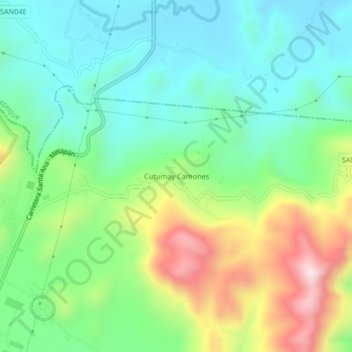
Name: Cutumay Camones topographic map, elevation, terrain.
Average elevation: 1,808 ft
Minimum elevation: 1,227 ft
Maximum elevation: 3,035 ft
Thank you for supporting this site ❤️
Make a donation
Make a donation
Gear up for your next adventure:
As an Amazon Associate, this site earns from qualifying purchases at no extra cost to you.
Other topographic maps
Click on a map to view its topography, its elevation and its terrain.
Santa Ana
El Salvador > Departamento de Santa Ana > Municipio de Santa Ana
The highest elevation in the town is the Santa Ana volcano (which measures 2365.07 m).
Average elevation: 2,336 ft