
Thank you for supporting this site ❤️
Make a donation
Make a donation
Gear up for your next adventure:
As an Amazon Associate, this site earns from qualifying purchases at no extra cost to you.
Sint-Joris topographic map
Click on the map to display elevation.
Thank you for supporting this site ❤️
Make a donation
Make a donation
Gear up for your next adventure:
As an Amazon Associate, this site earns from qualifying purchases at no extra cost to you.
About this map
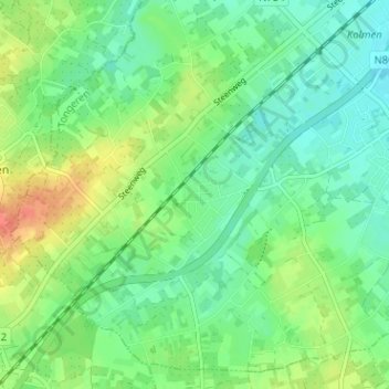
Name: Sint-Joris topographic map, elevation, terrain.
Location: Sint-Joris, Alken, Tongeren, Limburg, Vlaanderen, 3570, België (50.85198 5.25230 50.89198 5.29230)
Average elevation: 161 ft
Minimum elevation: 108 ft
Maximum elevation: 259 ft
Thank you for supporting this site ❤️
Make a donation
Make a donation
Gear up for your next adventure:
As an Amazon Associate, this site earns from qualifying purchases at no extra cost to you.