Geolocate

Mena topographic map

Click on the map to display elevation.

About this map

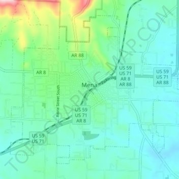
Name: Mena topographic map, elevation, terrain.

Location: Mena, Polk County, Arkansas, 72953, United States (34.55963 -94.26712 34.60503 -94.20068)

Average elevation: 1,165 ft

Minimum elevation: 1,001 ft

Maximum elevation: 1,814 ft

Polk County trails, hiking, mountain biking, running and outdoor activities

Other topographic maps

Click on a map to view its topography, its elevation and its terrain.

Black Fork Mountain

United States > Arkansas > Polk County

Average elevation: 1,900 ft

Big Fork

United States > Arkansas > Polk County

Average elevation: 1,158 ft

Ouachita River

United States > Arkansas > Polk County > Rich Mountain

Average elevation: 1,896 ft

Acorn

United States > Arkansas > Polk County

Average elevation: 1,152 ft

Gear up for your next adventure:

🎒Gear Packing Cubes - Organize your backpack efficiently
🩹Survival Bandages - High‑quality bandages for emergencies
🪶Thermal Camp Blanket - Extra warmth for cold nights
🏫Relief Map Kits - Hands-on tools for teaching landforms and elevation
🔭Stargazing Telescopes - Perfect for camping in low-light pollution areas shown on maps

As an Amazon Associate, this site earns from qualifying purchases at no extra cost to you.