
Thank you for supporting this site ❤️
Make a donation
Make a donation
Gear up for your next adventure:
As an Amazon Associate, this site earns from qualifying purchases at no extra cost to you.
Quitumbe topographic map
Click on the map to display elevation.
Thank you for supporting this site ❤️
Make a donation
Make a donation
Gear up for your next adventure:
As an Amazon Associate, this site earns from qualifying purchases at no extra cost to you.
About this map
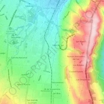
Name: Quitumbe topographic map, elevation, terrain.
Location: Quitumbe, Quito, Quito Canton, Pichincha, Ecuador (-0.32791 -78.55938 -0.27927 -78.51298)
Average elevation: 9,793 ft
Minimum elevation: 9,364 ft
Maximum elevation: 10,443 ft
Thank you for supporting this site ❤️
Make a donation
Make a donation
Gear up for your next adventure:
As an Amazon Associate, this site earns from qualifying purchases at no extra cost to you.
Other topographic maps
Click on a map to view its topography, its elevation and its terrain.