Geolocate

Quitumbe topographic map

Click on the map to display elevation.

About this map

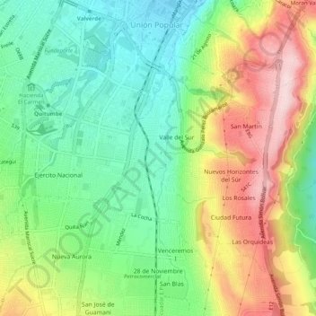
Name: Quitumbe topographic map, elevation, terrain.

Location: Quitumbe, Quito, Quito Canton, Pichincha, Ecuador (-0.32791 -78.55938 -0.27927 -78.51298)

Average elevation: 9,793 ft

Minimum elevation: 9,364 ft

Maximum elevation: 10,443 ft

Other topographic maps

Click on a map to view its topography, its elevation and its terrain.

2 Puentes

Ecuador > Pichincha > Quito Canton > Quito

Average elevation: 9,751 ft

Gear up for your next adventure:

🔌USB Car Charger - Car charger for on‑the‑go power needs
🧭Pro Hiking Compasses - High-accuracy liquid-filled compasses for topographic orientation
🖼️Topo Map Wall Art - Decorative topographic prints of famous peaks and regions
📡Handheld GPS Device - Reliable handheld GPS for outdoor navigation
🧯Portable Fire Pit - Compact fire pit for camping spots

As an Amazon Associate, this site earns from qualifying purchases at no extra cost to you.