
Make a donation
Gear up for your next adventure:
As an Amazon Associate, this site earns from qualifying purchases at no extra cost to you.
Candler-McAfee topographic map
Click on the map to display elevation.
Make a donation
Gear up for your next adventure:
As an Amazon Associate, this site earns from qualifying purchases at no extra cost to you.
About this map
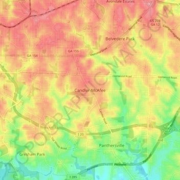
Name: Candler-McAfee topographic map, elevation, terrain.
Location: Candler-McAfee, DeKalb County, Georgia, 30032, United States (33.69192 -84.32341 33.77192 -84.24341)
Average elevation: 945 ft
Minimum elevation: 748 ft
Maximum elevation: 1,096 ft
DeKalb County trails, hiking, mountain biking, running and outdoor activities
Make a donation
Gear up for your next adventure:
As an Amazon Associate, this site earns from qualifying purchases at no extra cost to you.
Other topographic maps
Click on a map to view its topography, its elevation and its terrain.
Make a donation
Gear up for your next adventure:
As an Amazon Associate, this site earns from qualifying purchases at no extra cost to you.