Geolocate

Doraville topographic map

Click on the map to display elevation.

About this map

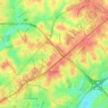
Name: Doraville topographic map, elevation, terrain.

Location: Doraville, DeKalb County, Georgia, 30063, United States (33.88141 -84.29086 33.93121 -84.23861)

Average elevation: 1,007 ft

Minimum elevation: 889 ft

Maximum elevation: 1,083 ft

DeKalb County trails, hiking, mountain biking, running and outdoor activities

Other topographic maps

Click on a map to view its topography, its elevation and its terrain.

North Druid Hills

United States > Georgia > DeKalb County

Average elevation: 955 ft

Brook Run Park

United States > Georgia > DeKalb County > Dunwoody

Average elevation: 1,001 ft

Redan

United States > Georgia > DeKalb County

Average elevation: 928 ft

WSB-FM (Atlanta)

United States > Georgia > DeKalb County > Atlanta

Average elevation: 1,007 ft

Dunwoody

United States > Georgia > DeKalb County > Dunwoody

Average elevation: 1,014 ft

Scottdale

United States > Georgia > DeKalb County

Average elevation: 991 ft

Windwood

United States > Georgia > DeKalb County > Dunwoody

Average elevation: 1,007 ft

Candler-McAfee

United States > Georgia > DeKalb County

Average elevation: 945 ft

Habersham

United States > Georgia > DeKalb County

Average elevation: 1,001 ft

Henrico

United States > Georgia > DeKalb County > Henrico

Average elevation: 883 ft

Gear up for your next adventure:

🗺️NatGeo Topo Maps - High-quality waterproof printed topographic maps of US Parks
🛌Ultralight Sleeping Bags - Compact down bags for cold nights in the wilderness
🔌USB Car Charger - Car charger for on‑the‑go power needs
📶Vehicle Signal Boosters - Improve reception in rural areas while driving to trailheads
🥇GPS Hiking Watch - Multi‑sport GPS watch with navigation and trail tracking

As an Amazon Associate, this site earns from qualifying purchases at no extra cost to you.