Geolocate

Alawihao topographic map

Click on the map to display elevation.

About this map

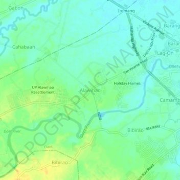
Name: Alawihao topographic map, elevation, terrain.

Location: Alawihao, Camarines Norte, Bicol Region, 4602, Philippines (14.08935 122.90910 14.12935 122.94910)

Average elevation: 49 ft

Minimum elevation: 20 ft

Maximum elevation: 95 ft

Other topographic maps

Click on a map to view its topography, its elevation and its terrain.

Daet River

Philippines > Camarines Norte > Daet > Bibirao

Average elevation: 62 ft

Daet River

Philippines > Camarines Norte > Daet

Average elevation: 10 ft

Bagasbas Beach

Philippines > Camarines Norte > Daet

Average elevation: 3 ft

Vinzons

Philippines > Camarines Norte

Average elevation: 33 ft

Paracale

Philippines > Camarines Norte

Average elevation: 36 ft

Gear up for your next adventure:

🛰️Handheld GPS Units - Professional satellite navigators for precise backcountry mapping
GPS Sports Watch - GPS watch for running, hiking and training
🌧️Backpack Rain Cover - Keep gear dry in wet weather
🏥Hiking First Aid Kits - Comprehensive medical kits for remote trail injuries
🧼Biodegradable Camping Soap - Eco‑friendly soap for outdoor hygiene

As an Amazon Associate, this site earns from qualifying purchases at no extra cost to you.