
Bekkaria topographic map
Interactive map
Click on the map to display elevation.
About this map
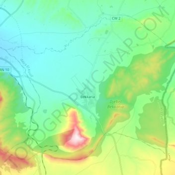
Name: Bekkaria topographic map, elevation, terrain.
Location: Bekkaria, daïra El Kouif, Tébessa, Algérie (35.32493 8.16158 35.43859 8.32986)
Average elevation: 3,268 ft
Minimum elevation: 2,684 ft
Maximum elevation: 5,059 ft
Other topographic maps
Click on a map to view its topography, its elevation and its terrain.
Boulhaf Dir
Algérie > Tébessa > daïra El Kouif > Boulhaf Dir
Boulhaf Dir, daïra El Kouif, Tébessa, Algérie
Average elevation: 2,989 ft