
Make a donation
Gear up for your next adventure:
As an Amazon Associate, this site earns from qualifying purchases at no extra cost to you.
Waverly Township topographic map
Click on the map to display elevation.
Make a donation
Gear up for your next adventure:
As an Amazon Associate, this site earns from qualifying purchases at no extra cost to you.
About this map
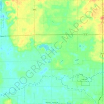
Name: Waverly Township topographic map, elevation, terrain.
Location: Waverly Township, Van Buren County, Michigan, United States (42.24395 -85.99434 42.33211 -85.87866)
Average elevation: 722 ft
Minimum elevation: 666 ft
Maximum elevation: 827 ft
Van Buren County trails, hiking, mountain biking, running and outdoor activities
Make a donation
Gear up for your next adventure:
As an Amazon Associate, this site earns from qualifying purchases at no extra cost to you.
Other topographic maps
Click on a map to view its topography, its elevation and its terrain.
Christie Lake
United States > Michigan > Van Buren County > Lawrence Township
Average elevation: 781 ft
Make a donation
Gear up for your next adventure:
As an Amazon Associate, this site earns from qualifying purchases at no extra cost to you.
Maple Grove Corners
United States > Michigan > Van Buren County > South Haven Charter Township
Average elevation: 646 ft