
Make a donation
Gear up for your next adventure:
As an Amazon Associate, this site earns from qualifying purchases at no extra cost to you.
Vorarlberg topographic map
Click on the map to display elevation.
Make a donation
Gear up for your next adventure:
As an Amazon Associate, this site earns from qualifying purchases at no extra cost to you.
Vorarlberg
The highest mountain is the Piz Buin, whose rocky peak of 3,312 m (10,866 ft) is surrounded by glaciers. The distance from Lake Constance and the plains of the Alpine Rhine valley across the medium altitude and high Alpine zones to the glaciers of the Silvretta range is a mere 90 km (56 mi).
Make a donation
Gear up for your next adventure:
As an Amazon Associate, this site earns from qualifying purchases at no extra cost to you.
About this map
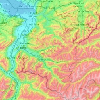
Name: Vorarlberg topographic map, elevation, terrain.
Location: Vorarlberg, Austria (46.84086 9.53075 47.59610 10.23716)
Average elevation: 4,534 ft
Minimum elevation: 1,286 ft
Maximum elevation: 11,109 ft
Make a donation
Gear up for your next adventure:
As an Amazon Associate, this site earns from qualifying purchases at no extra cost to you.
Other topographic maps
Click on a map to view its topography, its elevation and its terrain.
Vienna
Vienna is located in northeastern Austria, at the easternmost extension of the Alps in the Vienna Basin. The earliest settlement, at the location of today's inner city, was south of the meandering Danube while the city now spans both sides of the river. Elevation ranges from 151 to 542 m (495 to 1,778 ft). The…
Average elevation: 758 ft