
Make a donation
Gear up for your next adventure:
As an Amazon Associate, this site earns from qualifying purchases at no extra cost to you.
Cetona topographic map
Click on the map to display elevation.
Make a donation
Gear up for your next adventure:
As an Amazon Associate, this site earns from qualifying purchases at no extra cost to you.
Cetona
The geographical elevation is between 250 metres (820 ft) and the 1,148 metres (3,766 ft) of Monte Cetona itself, at the base of which the town is situated at around 350 metres (1,150 ft).
Make a donation
Gear up for your next adventure:
As an Amazon Associate, this site earns from qualifying purchases at no extra cost to you.
About this map
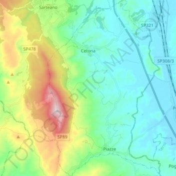
Name: Cetona topographic map, elevation, terrain.
Average elevation: 1,519 ft
Minimum elevation: 784 ft
Maximum elevation: 3,704 ft
Make a donation
Gear up for your next adventure:
As an Amazon Associate, this site earns from qualifying purchases at no extra cost to you.
Other topographic maps
Click on a map to view its topography, its elevation and its terrain.