
Moroto topographic map
Click on the map to display elevation.
Moroto
Moroto is located approximately 528 kilometres (328 mi), by road, northeast of Kampala, the capital and largest city of Uganda. The geographical coordinates of Moroto Town are 2°31'48.0"N, 34°40'12.0"E (Latitude:2.5300; Longitude:34.6700). Moroto sits at an average elevation of 1,370 metres (4,490 ft) above mean sea level.
About this map
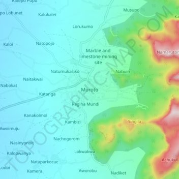
Name: Moroto topographic map, elevation, terrain.
Location: Moroto, Northern Region, Uganda (2.48862 34.61873 2.56862 34.69873)
Average elevation: 4,688 ft
Minimum elevation: 4,180 ft
Maximum elevation: 6,900 ft