
Westvale topographic map
Click on the map to display elevation.
About this map
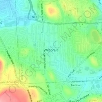
Name: Westvale topographic map, elevation, terrain.
Average elevation: 551 ft
Minimum elevation: 430 ft
Maximum elevation: 801 ft
Onondaga County trails, hiking, mountain biking, running and outdoor activities
Other topographic maps
Click on a map to view its topography, its elevation and its terrain.
Skanondaga Heights
United States > New York > Onondaga County > Town of Skaneateles
Average elevation: 955 ft
Howlett Hill
United States > New York > Onondaga County > Town of Marcellus
Average elevation: 1,050 ft
Skaneateles Lake
United States > New York > Onondaga County > Town of Skaneateles
Skaneateles Lake (/ˌskæniˈætləs/ SKAN-ee-AT-ləs, locally /ˌskɪn-/ SKIN-) is one of the Finger Lakes in central New York in the United States. The name Skaneateles means long lake in one of the local Iroquoian languages. The lake is sometimes referred to as "The Roof Garden of the Lakes" because its…
Average elevation: 1,145 ft
Borodino
United States > New York > Onondaga County > Town of Spafford > Borodino
Average elevation: 1,073 ft
Pitcher Hill
United States > New York > Onondaga County > Town of Salina > Pitcher Hill
Average elevation: 417 ft
Heath Grove
United States > New York > Onondaga County > Town of Otisco > Heath Grove
Average elevation: 965 ft
Stiles
United States > New York > Onondaga County > Town of Van Buren > Stiles
Average elevation: 427 ft
Howlett Hill
United States > New York > Onondaga County > Town of Onondaga > Howlett Hill
Average elevation: 889 ft
Onondaga Hill
United States > New York > Onondaga County > Town of Onondaga > Onondaga Hill
Average elevation: 797 ft
Spafford Valley
United States > New York > Onondaga County > Town of Spafford
Average elevation: 1,263 ft