Geolocate

Experiment topographic map

Click on the map to display elevation.

About this map

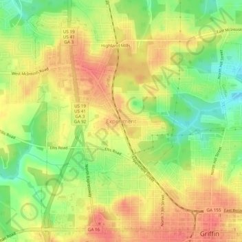
Name: Experiment topographic map, elevation, terrain.

Location: Experiment, Spalding County, Georgia, 30223, United States (33.24539 -84.30159 33.28539 -84.26159)

Average elevation: 919 ft

Minimum elevation: 807 ft

Maximum elevation: 997 ft

Spalding County trails, hiking, mountain biking, running and outdoor activities

Other topographic maps

Click on a map to view its topography, its elevation and its terrain.

Orchard Hill

United States > Georgia > Spalding County

Average elevation: 830 ft

Gear up for your next adventure:

🛰️Satellite Messengers - Emergency SOS and two-way messaging for off-grid adventures
📌Outdoor GPS Map App - Apps and devices for digital topographic navigation
🪓Survival Multi‑Tool - Versatile tool for camp and trail tasks
🚗GPS Dash Cams - Record your scenic drives through mountain passes and canyons
🔭Compact Binoculars - HD vision for scouting terrain and identifying distant landmarks

As an Amazon Associate, this site earns from qualifying purchases at no extra cost to you.