Geolocate

Bowdon topographic map

Click on the map to display elevation.

About this map

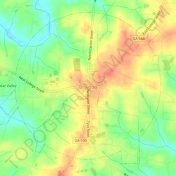
Name: Bowdon topographic map, elevation, terrain.

Location: Bowdon, Carroll County, Georgia, 30108, United States (33.52273 -85.27769 33.55265 -85.23609)

Average elevation: 1,047 ft

Minimum elevation: 958 ft

Maximum elevation: 1,125 ft

Carroll County trails, hiking, mountain biking, running and outdoor activities

Other topographic maps

Click on a map to view its topography, its elevation and its terrain.

Driskolls

United States > Georgia > Carroll County > Villa Rica

Average elevation: 1,099 ft

Star Point

United States > Georgia > Carroll County

Average elevation: 1,020 ft

Gear up for your next adventure:

🎒Gear Packing Cubes - Organize your backpack efficiently
🛰️Satellite Messengers - Emergency SOS and two-way messaging for off-grid adventures
🧤Tactile Hiking Gloves - Keep hands warm while operating GPS and smartphone screens
🧣Merino Neck Gaiters - Multi-functional headwear for wind and sun protection
🚑Emergency Bivvies - Heat-reflective sleeping bags for survival situations

As an Amazon Associate, this site earns from qualifying purchases at no extra cost to you.