
Thank you for supporting this site ❤️
Make a donation
Make a donation
Gear up for your next adventure:
As an Amazon Associate, this site earns from qualifying purchases at no extra cost to you.
Ramiano topographic map
Click on the map to display elevation.
Thank you for supporting this site ❤️
Make a donation
Make a donation
Gear up for your next adventure:
As an Amazon Associate, this site earns from qualifying purchases at no extra cost to you.
About this map
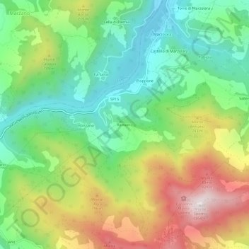
Name: Ramiano topographic map, elevation, terrain.
Location: Ramiano, Calestano, Parma, Emilia-Romagna, Italia (44.59375 10.14218 44.63375 10.18218)
Average elevation: 1,939 ft
Minimum elevation: 1,001 ft
Maximum elevation: 3,419 ft
Thank you for supporting this site ❤️
Make a donation
Make a donation
Gear up for your next adventure:
As an Amazon Associate, this site earns from qualifying purchases at no extra cost to you.