
Make a donation
Gear up for your next adventure:
As an Amazon Associate, this site earns from qualifying purchases at no extra cost to you.
Ergoiena topographic map
Click on the map to display elevation.
Make a donation
Gear up for your next adventure:
As an Amazon Associate, this site earns from qualifying purchases at no extra cost to you.
Ergoiena
Ergoyena forma una especie de ramal o desvío del valle de La Barranca. Se encuentra situado a algo más altitud que el resto de pueblos vecinos de la comarca, que ocupan el fondo del valle, así Lizarraga se encuentra a 589 m de altura, frente a los 508 m de Echarri Aranaz o los 515 m de Bacáicoa. De ahí se cree que deriva el nombre de Ergoyena.
Make a donation
Gear up for your next adventure:
As an Amazon Associate, this site earns from qualifying purchases at no extra cost to you.
About this map
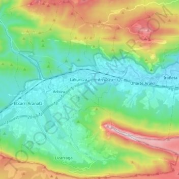
Name: Ergoiena topographic map, elevation, terrain.
Location: Ergoiena, Sakana, Navarra, España (42.86126 -2.08901 42.97077 -1.93912)
Average elevation: 2,503 ft
Minimum elevation: 1,483 ft
Maximum elevation: 4,862 ft
Make a donation
Gear up for your next adventure:
As an Amazon Associate, this site earns from qualifying purchases at no extra cost to you.
Other topographic maps
Click on a map to view its topography, its elevation and its terrain.