Geolocate

Carlyle topographic map

Click on the map to display elevation.

About this map

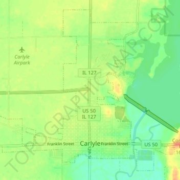
Name: Carlyle topographic map, elevation, terrain.

Location: Carlyle, Clinton County, Illinois, United States (38.60285 -89.40557 38.64642 -89.34338)

Average elevation: 459 ft

Minimum elevation: 400 ft

Maximum elevation: 525 ft

Clinton County trails, hiking, mountain biking, running and outdoor activities

Other topographic maps

Click on a map to view its topography, its elevation and its terrain.

Carlyle

United States > Illinois > Clinton County > Carlyle > Carlyle

Average elevation: 453 ft

Gear up for your next adventure:

🎒Outdoor Daypacks - Lightweight backpacks designed for carrying maps and essential gear
🛠️Backpacking Tool Kit - Essential toolkit for outdoor repairs
🪶Camping Sleeping Pad - Comfortable sleeping pad for backpacking
📚Navigation Handbooks - Master the art of reading topographic maps and using a compass
🧥Waterproof Jacket for Hiking - Breathable and rugged rain jacket for outdoor excursions

As an Amazon Associate, this site earns from qualifying purchases at no extra cost to you.