Geolocate

Eartham topographic map

Click on the map to display elevation.

About this map

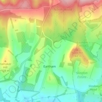
Name: Eartham topographic map, elevation, terrain.

Location: Eartham, Chichester, West Sussex, England, United Kingdom (50.86329 -0.69403 50.90242 -0.64981)

Average elevation: 295 ft

Minimum elevation: 92 ft

Maximum elevation: 620 ft

Gear up for your next adventure:

🧭Hiking Compass - Precision compass for reliable navigation in the wilderness
🥘Titanium Cookware - Durable, featherlight pots and pans for backpacking
🪑Portable Camp Table - Compact table for campsite meals
🔥Plasma Lighters - Windproof lighters that work in any weather condition
🪶Camping Sleeping Pad - Comfortable sleeping pad for backpacking

As an Amazon Associate, this site earns from qualifying purchases at no extra cost to you.