Geolocate

Garvald topographic map

Click on the map to display elevation.

About this map

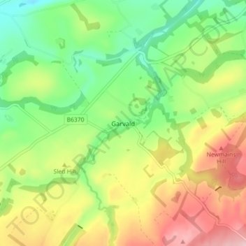
Name: Garvald topographic map, elevation, terrain.

Location: Garvald, East Lothian, Scotland, EH41 4LN, United Kingdom (55.90882 -2.68106 55.94882 -2.64106)

Average elevation: 551 ft

Minimum elevation: 246 ft

Maximum elevation: 968 ft

Other topographic maps

Click on a map to view its topography, its elevation and its terrain.

Firth of Forth

United Kingdom > Scotland > East Lothian

Average elevation: 285 ft

Lammermuirs

United Kingdom > Scotland > East Lothian

Average elevation: 873 ft

Bass Rock

United Kingdom > Scotland > East Lothian

Average elevation: 0 ft

River Esk

United Kingdom > Scotland > East Lothian > Musselburgh

Average elevation: 23 ft

Coldale Wood

United Kingdom > Scotland > East Lothian

Average elevation: 213 ft

Gear up for your next adventure:

🗺️Topographic Maps - Detailed topo maps for hiking, exploring and outdoor navigation
☀️Outdoor Sunscreen - High protection sunscreen for outdoor activities
🧤Tactile Hiking Gloves - Keep hands warm while operating GPS and smartphone screens
🧥Waterproof Jacket for Hiking - Breathable and rugged rain jacket for outdoor excursions
🧢Outdoor Hiking Hat - Sun protection hat for outdoor explorers

As an Amazon Associate, this site earns from qualifying purchases at no extra cost to you.