
Make a donation
Gear up for your next adventure:
As an Amazon Associate, this site earns from qualifying purchases at no extra cost to you.
Franklin topographic map
Click on the map to display elevation.
Make a donation
Gear up for your next adventure:
As an Amazon Associate, this site earns from qualifying purchases at no extra cost to you.
About this map
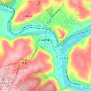
Name: Franklin topographic map, elevation, terrain.
Location: Franklin, Venango County, Pennsylvania, United States (41.37218 -79.87276 41.41791 -79.81746)
Average elevation: 1,240 ft
Minimum elevation: 932 ft
Maximum elevation: 1,549 ft
Venango County trails, hiking, mountain biking, running and outdoor activities
Make a donation
Gear up for your next adventure:
As an Amazon Associate, this site earns from qualifying purchases at no extra cost to you.
Other topographic maps
Click on a map to view its topography, its elevation and its terrain.
Tyrrel Farm Corners
United States > Pennsylvania > Venango County > Allegheny Township
Average elevation: 1,568 ft
Owltown
United States > Pennsylvania > Venango County > Cornplanter Township
Average elevation: 1,457 ft
Pine Hill
United States > Pennsylvania > Venango County > Pinegrove Township
Average elevation: 1,568 ft
Make a donation
Gear up for your next adventure:
As an Amazon Associate, this site earns from qualifying purchases at no extra cost to you.
President
United States > Pennsylvania > Venango County > President Township
Average elevation: 1,283 ft
Five Points
United States > Pennsylvania > Venango County > Victory Township
Average elevation: 1,440 ft