
Thank you for supporting this site ❤️
Make a donation
Make a donation
Gear up for your next adventure:
As an Amazon Associate, this site earns from qualifying purchases at no extra cost to you.
Shafa Amr topographic map
Click on the map to display elevation.
Thank you for supporting this site ❤️
Make a donation
Make a donation
Gear up for your next adventure:
As an Amazon Associate, this site earns from qualifying purchases at no extra cost to you.
About this map
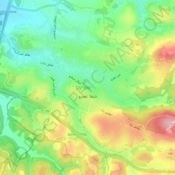
Name: Shafa Amr topographic map, elevation, terrain.
Location: Shafa Amr, Acre Subdistrict, North District, Israel (32.79044 35.14987 32.82229 35.19541)
Average elevation: 390 ft
Minimum elevation: 125 ft
Maximum elevation: 774 ft
Thank you for supporting this site ❤️
Make a donation
Make a donation
Gear up for your next adventure:
As an Amazon Associate, this site earns from qualifying purchases at no extra cost to you.