Geolocate

Paramonga topographic map

Click on the map to display elevation.

About this map
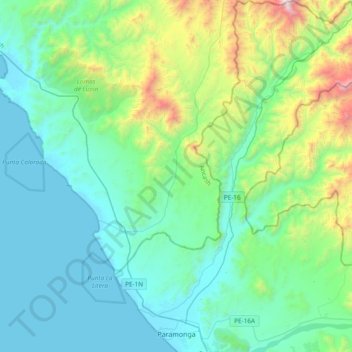
Name: Paramonga topographic map, elevation, terrain.

Location: Paramonga, Province of Barranca, Lima, 15178, Peru (-10.69455 -77.88631 -10.32070 -77.59759)

Average elevation: 1,306 ft

Minimum elevation: 0 ft

Maximum elevation: 6,870 ft

Other topographic maps

Click on a map to view its topography, its elevation and its terrain.

Rupac

Peru > Lima > Atavillos Bajo > Piscocoto

Average elevation: 10,210 ft

La Ensenada

Peru > Lima > Sayán

Average elevation: 1,388 ft

Naplo

Peru > Lima > Lima Metropolitan Area

Average elevation: 108 ft

Llawa P'ukru

Peru > Lima > Chicla

Average elevation: 16,119 ft

80

Peru > Lima > Lima Metropolitan Area

Average elevation: 1,135 ft

Lampay

Peru > Lima > Paramonga

Average elevation: 233 ft

Tinco - Alis

Peru > Lima

Average elevation: 11,686 ft

Santa Rosa de Cata

Peru > Lima > Coayllo

Average elevation: 3,848 ft

Calusa

Peru > Lima > Huaura

Average elevation: 1,073 ft

Playa La Herradura

Peru > Lima > Chorrillos

Average elevation: 171 ft

D6a

Peru > Lima > Lima Metropolitan Area

Average elevation: 354 ft

Esteban

Peru > Lima > Végueta

Average elevation: 489 ft

Gear up for your next adventure:

📱Heavy-Duty Phone Cases - Drop-proof and waterproof protection for outdoor navigation
🛌Ultralight Sleeping Bags - Compact down bags for cold nights in the wilderness
🌡️Portable Weather Meter - Track weather conditions on the trail
🧴Hand Sanitizer - Keep hands clean while hiking
📷Action Camera - Capture your outdoor adventures in HD

As an Amazon Associate, this site earns from qualifying purchases at no extra cost to you.