Geolocate

Pinar del Rio topographic map

Click on the map to display elevation.

About this map

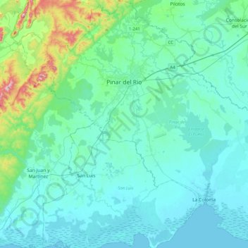
Name: Pinar del Rio topographic map, elevation, terrain.

Location: Pinar del Rio, Cuba (22.16974 -83.82653 22.53734 -83.44413)

Average elevation: 184 ft

Minimum elevation: -7 ft

Maximum elevation: 1,381 ft

Gear up for your next adventure:

🔪Outdoor Multitools - Essential survival tools for gear repair and field use
🌧️Backpack Rain Cover - Keep gear dry in wet weather
🔦LED Headlamp - Bright and durable LED headlamp for night navigation
🪶Multi‑Purpose Knife - Useful blade for camp and trail
🖼️Topo Map Wall Art - Decorative topographic prints of famous peaks and regions

As an Amazon Associate, this site earns from qualifying purchases at no extra cost to you.