
Thank you for supporting this site ❤️
Make a donation
Make a donation
Gear up for your next adventure:
As an Amazon Associate, this site earns from qualifying purchases at no extra cost to you.
Mbuji-Mayi topographic map
Click on the map to display elevation.
Thank you for supporting this site ❤️
Make a donation
Make a donation
Gear up for your next adventure:
As an Amazon Associate, this site earns from qualifying purchases at no extra cost to you.
About this map
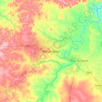
Name: Mbuji-Mayi topographic map, elevation, terrain.
Average elevation: 2,037 ft
Minimum elevation: 1,509 ft
Maximum elevation: 2,667 ft
Thank you for supporting this site ❤️
Make a donation
Make a donation
Gear up for your next adventure:
As an Amazon Associate, this site earns from qualifying purchases at no extra cost to you.
Other topographic maps
Click on a map to view its topography, its elevation and its terrain.
RVA
Democratic Republic of the Congo > Kasai-Oriental > Ville de Mbujimayi
Average elevation: 2,251 ft
Dieu soit Béni
Democratic Republic of the Congo > Kasai-Oriental > Ville de Mbujimayi
Average elevation: 1,795 ft