
Make a donation
Gear up for your next adventure:
As an Amazon Associate, this site earns from qualifying purchases at no extra cost to you.
Smetlede topographic map
Click on the map to display elevation.
Make a donation
Gear up for your next adventure:
As an Amazon Associate, this site earns from qualifying purchases at no extra cost to you.
Smetlede
Smetlede ligt in Zandig- en Zandlemig Vlaanderen. De hoogte bedraagt 13-37 meter. De Wellebeek die er stroomt behoort tot het stroomgebied van de Molenbeek.
Make a donation
Gear up for your next adventure:
As an Amazon Associate, this site earns from qualifying purchases at no extra cost to you.
About this map
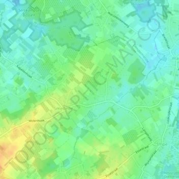
Name: Smetlede topographic map, elevation, terrain.
Location: Smetlede, Lede, Aalst, Oost-Vlaanderen, België (50.95467 3.90848 50.98354 3.94846)
Average elevation: 72 ft
Minimum elevation: 30 ft
Maximum elevation: 148 ft
Make a donation
Gear up for your next adventure:
As an Amazon Associate, this site earns from qualifying purchases at no extra cost to you.