Geolocate

Leonberg topographic map

Click on the map to display elevation.

About this map

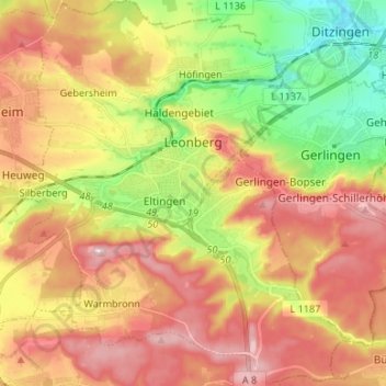
Name: Leonberg topographic map, elevation, terrain.

Location: Leonberg, Landkreis Böblingen, Baden-Württemberg, 71229, Germany (48.74587 8.95713 48.83350 9.06881)

Average elevation: 1,355 ft

Minimum elevation: 961 ft

Maximum elevation: 1,709 ft

Gear up for your next adventure:

🥾Women's Hiking Boots - Top-rated trail boots with ankle support and superior grip
📱Solar Portable Charger - Solar power bank for charging devices off‑grid
🧼Biodegradable Camping Soap - Eco‑friendly soap for outdoor hygiene
🦶Carbon Trekking Poles - Reduce knee impact on steep descents with ultra-light poles
🛏️Cold Weather Sleeping Bag - Warm sleeping bag for cold conditions

As an Amazon Associate, this site earns from qualifying purchases at no extra cost to you.