Geolocate

Patia topographic map

Click on the map to display elevation.

About this map

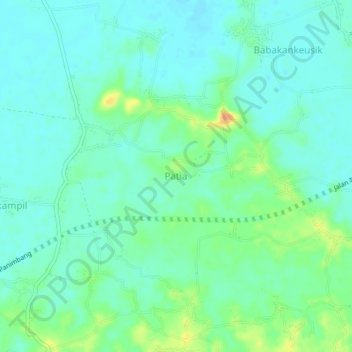
Name: Patia topographic map, elevation, terrain.

Location: Patia, Banten, Indonesia (-6.51153 105.84964 -6.47153 105.88964)

Average elevation: 43 ft

Minimum elevation: 7 ft

Maximum elevation: 131 ft

Gear up for your next adventure:

🔋Rechargeable Batteries - Power up your outdoor devices
🏔️Mountain Trail Maps - High‑detail maps for popular peaks
GPS Sports Watch - GPS watch for running, hiking and training
🛠️Outdoor Gear Repair Kit - Essential tools to fix gear on the trail
🧦Hiking Socks - Comfortable socks to prevent blisters on long hikes

As an Amazon Associate, this site earns from qualifying purchases at no extra cost to you.