
Thank you for supporting this site ❤️
Make a donation
Make a donation
Gear up for your next adventure:
As an Amazon Associate, this site earns from qualifying purchases at no extra cost to you.
Doberburg topographic map
Click on the map to display elevation.
Thank you for supporting this site ❤️
Make a donation
Make a donation
Gear up for your next adventure:
As an Amazon Associate, this site earns from qualifying purchases at no extra cost to you.
Doberburg
Auf der Gemarkung Doberburg liegen die Wohnplätze Friedrichshöhe und Baroldmühle. Der im 19. Jahrhundert genannte Sieheshof im äußersten nördlichen Zipfel der Gemarkung Doberburg existiert nicht mehr.
Thank you for supporting this site ❤️
Make a donation
Make a donation
Gear up for your next adventure:
As an Amazon Associate, this site earns from qualifying purchases at no extra cost to you.
About this map
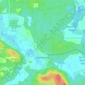
Name: Doberburg topographic map, elevation, terrain.
Average elevation: 177 ft
Minimum elevation: 138 ft
Maximum elevation: 322 ft
Thank you for supporting this site ❤️
Make a donation
Make a donation
Gear up for your next adventure:
As an Amazon Associate, this site earns from qualifying purchases at no extra cost to you.