
Make a donation
Gear up for your next adventure:
As an Amazon Associate, this site earns from qualifying purchases at no extra cost to you.
Palmira topographic map
Click on the map to display elevation.
Make a donation
Gear up for your next adventure:
As an Amazon Associate, this site earns from qualifying purchases at no extra cost to you.
Palmira
Palmira is located in southwestern Colombia, lying in the Cauca River valley. 3°31’48” north altitude and 76°81’13” longitude west of Greenwich. The city covers an area of 1,160 km2 (448 sq mi). The city lies at an elevation of 1,000 m (3,300 ft) above sea level.
Make a donation
Gear up for your next adventure:
As an Amazon Associate, this site earns from qualifying purchases at no extra cost to you.
About this map
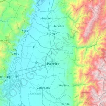
Name: Palmira topographic map, elevation, terrain.
Location: Palmira, Sur, Valle del Cauca, RAP Pacífico, Colombia (3.45160 -76.49174 3.71807 -75.94967)
Average elevation: 5,249 ft
Minimum elevation: 3,025 ft
Maximum elevation: 13,698 ft
Make a donation
Gear up for your next adventure:
As an Amazon Associate, this site earns from qualifying purchases at no extra cost to you.
Other topographic maps
Click on a map to view its topography, its elevation and its terrain.
Make a donation
Gear up for your next adventure:
As an Amazon Associate, this site earns from qualifying purchases at no extra cost to you.
Make a donation
Gear up for your next adventure:
As an Amazon Associate, this site earns from qualifying purchases at no extra cost to you.