
Make a donation
Gear up for your next adventure:
As an Amazon Associate, this site earns from qualifying purchases at no extra cost to you.
Hjelmeland topographic map
Click on the map to display elevation.
Make a donation
Gear up for your next adventure:
As an Amazon Associate, this site earns from qualifying purchases at no extra cost to you.
About this map
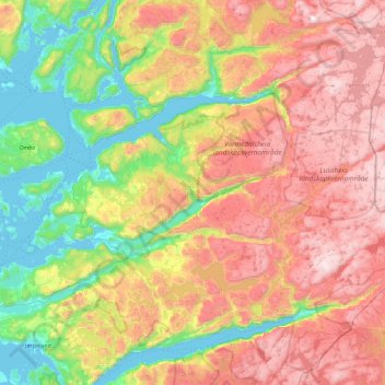
Name: Hjelmeland topographic map, elevation, terrain.
Location: Hjelmeland, Rogaland, Norway (59.03673 5.95215 59.37525 6.86514)
Average elevation: 1,867 ft
Minimum elevation: -7 ft
Maximum elevation: 4,400 ft
Make a donation
Gear up for your next adventure:
As an Amazon Associate, this site earns from qualifying purchases at no extra cost to you.
Other topographic maps
Click on a map to view its topography, its elevation and its terrain.
Pulpit Rock
The walk to Preikestolen is very steep in places. The path starts at the Preikestolhytta, at an elevation of approximately 270 metres (890 ft) above sea level, and climbs to 604 metres (1,982 ft). The walk takes 2–3 hours depending on traffic along the trail, experience, and fitness level. Even though the…
Average elevation: 948 ft
Make a donation
Gear up for your next adventure:
As an Amazon Associate, this site earns from qualifying purchases at no extra cost to you.