
Thank you for supporting this site ❤️
Make a donation
Make a donation
Gear up for your next adventure:
As an Amazon Associate, this site earns from qualifying purchases at no extra cost to you.
Choibalsan topographic map
Click on the map to display elevation.
Thank you for supporting this site ❤️
Make a donation
Make a donation
Gear up for your next adventure:
As an Amazon Associate, this site earns from qualifying purchases at no extra cost to you.
About this map
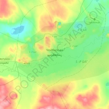
Name: Choibalsan topographic map, elevation, terrain.
Location: Choibalsan, Herlen, Dornod, Mongolia (47.98124 114.41179 48.14779 114.74212)
Average elevation: 2,500 ft
Minimum elevation: 2,343 ft
Maximum elevation: 2,782 ft
Thank you for supporting this site ❤️
Make a donation
Make a donation
Gear up for your next adventure:
As an Amazon Associate, this site earns from qualifying purchases at no extra cost to you.